Jul 10 2008
The new Leica ADS80 airborne digital sensor is superior to any other large-format digital airborne imaging technology available today.
 Leica ADS80 Airborne Digital Sensor: Best imagery ever.
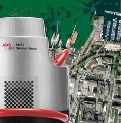
Two available configurations, Sensor Heads SH81 and SH82, support the widest range of geospatial applications from orthophoto to 3D feature mapping. The improved data throughput of the all new Control Unit CU80 with flash memory MM80 facilitates simultaneous data acquisition of equal resolution imagery in all bands for photogrammetry and remote sensing applications at even smaller GSD’s, offering you maximum flexibility and higher productivity.
“With the Leica ADS80 we not only introduce a new Digital Sensor to the market, but a whole new workflow the customer can benefit from,” says George Southard, Leica Geosystems’ Vice President Americas’ Digital Imaging
Together with Leica XPro: The most complete large-format sensor solution available
From flight planning with Leica FPES and data acquisition with the Sensor Heads SH81/82 to data delivery with new Leica XPro line sensor processing software, the Leica ADS80 represents a complete digital airborne imaging solution that is easy to use and fast to implement. It delivers increased flexibility, higher productivity and lower cost throughout the entire workflow. Since pan-sharpening and “virtual images” are not necessary, Leica Geosystems line sensor technology constitutes a viable and simple digital alternative to those familiar with the traditional analog workflow.
Productivity, Efficiency and Reliability
“Leica Geosystems’ RC30 and many other products have for decades set the gold standard for the geospatial industry. The Leica ADS80 airborne digital sensor follows in this tradition and is the complete sensor solution available from the industry leader. Our worldwide support network ensures that customers stay ahead of their competitors,” says George Southard, Leica Geosystems’ Vice President Americas’ Digital Imaging