Satellite-based forest monitoring is changing the way we approach conservation efforts and natural resource management. Optical satellites provide effective, scalable, and non-invasive solutions that support monitoring, enforcement, and ecosystem management goals worldwide. These satellites capture detailed imagery and critical data that support a wide range of stakeholders involved in ecosystem management. Recent advancements in optical satellite technologies have enhanced forest protection, boosting their real-world applications in conservation and resource planning.
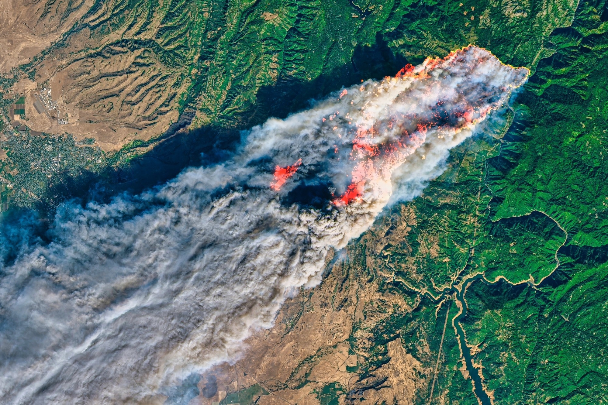
Image Credit: GREAT-BACKGROUNDS/Shutterstock.com
What Are Optical Satellite Technologies?
Optical satellite technologies refer to remote sensing instruments in space that capture sunlight reflected from the Earth's surface. These technologies differ from radar-based sensing, which utilizes radio waves to collect data regardless of weather conditions.1 There are three main types of optical sensors useful for studying forests.
- Multispectral sensors collect data across several broad wavelength bands, typically spanning visible to near-infrared regions. They are effective at identifying different types of vegetation, checking the health of canopies, and mapping land cover.2
- Hyperspectral sensors capture hundreds of contiguous narrow spectral bands, creating a detailed spectral fingerprint for each pixel. This allows for the identification of tree species, detection of minute changes in chlorophyll, and recognition of chemical indicators related to disease or stress.1
- Thermal infrared sensors measure emitted heat, which is critical for assessing water status and monitoring fire activity.3
Optical satellites offer wide-area coverage, repeated acquisitions over days to weeks, and a non-contact approach that avoids any disturbance to monitored ecosystems. The ability to revisit locations regularly establishes a baseline for long-term monitoring, making it far easier to measure incremental changes and persistent trends over decades.1,3
Download the PDF of the article
Commercial Applications in Forest Protection
Illegal Logging Detection
High-resolution optical satellites can identify fine-scale forest disturbances with a spatial precision that exposes even selective logging activities. Algorithms applied to time series of imagery can highlight abrupt changes in canopy closure, logging roads, or extraction patterns, providing irrefutable evidence for enforcement agencies. In Brazil, the National Institute for Space Research (INPE) relies on the DETER and PRODES optical monitoring systems to track deforestation in the Amazon. These systems provide near-real-time alerts that inform policy decisions and support legal enforcement efforts.4,5
Biodiversity Monitoring
Optical satellites capture not only tree cover but also signatures of habitat diversity, which are essential for tracking ecological health. By analyzing changes in spectral reflectance, researchers gauge understory structure, phenological cycles, and the impacts of disease or climate events on various vegetation strata. Advanced deep learning techniques can even count and classify animal populations in open landscapes, using very high-resolution multispectral imagery to monitor wildlife dynamics and evaluate ecosystem services.2
Fire Risk Mapping and Post-Fire Assessment
Visible and infrared sensors play a critical role in fire-prone environments. Satellites like Moderate Resolution Imaging Spectroradiometer (MODIS) and Visible Infrared Imaging Radiometer Suite (VIIRS) have special thermal channels that help detect fires early. This modality supports emergency response and risk mapping by quickly spotting ignition sources and monitoring the spread of wildfire fronts. Post-event, high-resolution optical imagery enables rapid assessment of burn scars, vegetation regrowth, and carbon emissions, which is further useful for planning restoration and prevention strategies.3,6
Carbon Accounting and REDD+ Compliance
International frameworks like Reducing Emissions from Deforestation and Forest Degradation (REDD+) depend on accurate, transparent quantification of forest carbon stocks and changes. Multispectral and hyperspectral satellites monitor important factors such as biomass, canopy structure, and vegetation density. These measurements are critical for robust carbon accounting. Programs coordinated by the European Union’s Copernicus initiative deliver public, high-resolution datasets from Sentinel-2 satellites to promote member state reporting and independent third-party verification.1,7
Real-World Conservation Initiatives
Brazil’s INPE, the EU’s Copernicus, and collaborative academic partners have led the use of optical satellite technology at the national and continental scales. These agencies integrate time series from Earth observation satellites to issue forest disturbance alerts, update land cover inventories, and provide decision support for protected area management and environmental compliance.1,3,5
Technology Spotlight: Companies Pioneering Optical Satellite Forest Monitoring
Planet Labs
Planet Labs has transformed daily satellite imaging with its fleet of nanosatellites, collectively known as “PlanetScope.” The constellation’s rapid revisit times and moderate resolution help users to detect logging incursions and habitat loss as soon as they occur. By continuously observing the Earth, the Planet’s satellites give important information to governments and NGOs targeting illegal activities and prioritizing conservation efforts.3
Airbus
Airbus operates the SPOT and Pleiades satellite series. SPOT provides broad imaging while Pleiades offers very high-resolution images. These satellites are important for classifying land cover, valuing ecosystem services, and monitoring disturbances in commercial forestry and conservation agencies.8,9
Maxar Technologies
Maxar’s WorldView Legion constellation sets high standards for spatial and spectral resolution. It can deliver detailed pictures at nearly one meter in visible and near-infrared bands. Maxar captures detailed mapping of forest edges, individual tree counts, and even wildlife monitoring in open canopies. Their analytics tools integrate artificial intelligence for automatic feature detection, making it easier to report changes in forests quickly.10
Data Platforms
Commercial data analytics platforms like Descartes Labs and Satelligence process large satellite datasets. Using cloud technology and unique algorithms, they make forest intelligence accessible. These services offer customized dashboards and Application Programming Interface (API)-based products for governments, agribusinesses, and researchers to analyze environmental data effectively.11,12
Challenges and Limitations
Despite remarkable progress, optical satellite technology faces several persistent challenges. In equatorial and temperate regions, persistent cloud cover and smoke can obscure optical imagery, reducing observation frequency and reliability during critical events like wildfire or deforestation surges. In dense or damaged forests, the technology struggles to detect small changes in plant life and biomass. This limits effective monitoring in these complex environments and reduces the accuracy of observations.1,3
Processing and interpreting very large volumes of high-resolution data requires a lot of computing power and specialized technical skills. Many small conservation NGOs lack the funding or infrastructure to procure commercial imagery or deploy state-of-the-art analytics. This can create inequalities in access and enforcement. Furthermore, while satellite data collection is global, ground-truth verification and field calibration remain critical for accurate interpretation, adding logistics hurdles in remote or insecure regions.1,3
Future Directions in Forest Surveillance
Recent advancements in optical satellite technology are rapidly addressing various associated challenges. The use of artificial intelligence and machine learning in satellite data provides automated deforestation alerts, biodiversity assessments, and fire risk modeling with increasing reliability and speed. Hyperspectral sensors, once only used in research, are now being miniaturized for use in nanosatellite constellations, which improves monitoring capabilities.
International cooperation is promoting easier access to optical satellite data. Efforts from space agencies and open-data groups are enabling more frequent and detailed forest monitoring worldwide. By lowering technical barriers and encouraging wider participation, these initiatives can improve transparency and accountability in forest conservation programs. With ongoing improvements in technology, these tools will continue to be crucial for protecting forests.
See how Raman spectroscopy can detect plant stress
References and Further Reading
- Fassnacht, F. E. et al. (2024). Remote sensing in forestry: Current challenges, considerations and directions. Forestry: An International Journal of Forest Research, 97(1), 11-37. DOI:10.1093/forestry/cpad024. https://academic.oup.com/forestry/article/97/1/11/7159227
- Wu, Z. et al. (2023). Deep learning enables satellite-based monitoring of large populations of terrestrial mammals across heterogeneous landscape. Nature Communications, 14(1), 1-15. DOI:10.1038/s41467-023-38901-y. https://www.nature.com/articles/s41467-023-38901-y
- He, J. et al. (2024). Recent advances and challenges in monitoring and modeling of disturbances in tropical moist forests. Frontiers in Remote Sensing, 5, 1332728. DOI:10.3389/frsen.2024.1332728. https://www.frontiersin.org/journals/remote-sensing/articles/10.3389/frsen.2024.1332728/full
- Aquino, C. et al. (2025). Detecting selective logging in tropical forests with optical satellite data: An experiment in Peru shows texture at 3 m gives the best results. Remote Sensing in Ecology and Conservation, 11(1), 100-118. DOI:10.1002/rse2.414. https://zslpublications.onlinelibrary.wiley.com/doi/full/10.1002/rse2.414
- Bourscheit, A. (2022). Prodes and Deter: get to know these strategic systems in the fight against deforestation in the Amazon. INFOAMAZONIA. https://infoamazonia.org/en/2022/02/15/prodes-and-deter-systems-against-deforestation-amazon/
- Nelson, D. M. et al. (2024). Trends and applications in wildfire burned area mapping: Remote sensing data, cloud geoprocessing platforms, and emerging algorithms. Geomatica, 76(1), 100008. DOI:10.1016/j.geomat.2024.100008. https://www.sciencedirect.com/science/article/pii/S1195103624000089
- Andoh, J. et al. (2022). Towards REDD+ implementation: Deforestation and forest degradation drivers, REDD+ financing, and readiness activities in participant countries. Frontiers in Forests and Global Change, 5, 957550. DOI:10.3389/ffgc.2022.957550. https://www.frontiersin.org/journals/forests-and-global-change/articles/10.3389/ffgc.2022.957550/full
- 50cm Very High-Resolution Imagery | Pléiades. Airbus Defence and Space. https://space-solutions.airbus.com/imagery/our-optical-and-radar-satellite-imagery/pleiades/
- 1.5m Satellite Imagery | SPOT. Airbus Defence and Space. https://space-solutions.airbus.com/imagery/our-optical-and-radar-satellite-imagery/spot/
- Buczkowski, A. (2025). How Maxar’s constellation is setting new standards in precision, change detection, and revisit capabilities. Geo Awesome. https://geoawesome.com/how-maxars-constellation-is-setting-new-standards-in-precision-change-detection-and-revisit-capabilities/
- Descartes Labs: Advancing global food security. Google Cloud. https://cloud.google.com/customers/descartes-labs
- Masselink, R. (2020). How we detect deforestation using satellite data. Satelligence. https://satelligence.com/how-we-detect-deforestation-using-satellite-data/
Disclaimer: The views expressed here are those of the author expressed in their private capacity and do not necessarily represent the views of AZoM.com Limited T/A AZoNetwork the owner and operator of this website. This disclaimer forms part of the Terms and conditions of use of this website.