Reviewed by Frances BriggsOct 28 2025
With stunning initial radar images of forests, farmland, and coastlines, NISAR has kicked off a new era in satellite-based Earth monitoring. The US-India partnership's data, delivered science-ready, could reshape how we respond to climate, disasters, and land use.
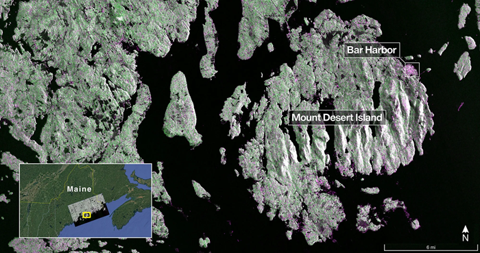 Captured on Aug. 21, this image from NISAR’s L-band radar shows Maine’s Mount Desert Island. Green indicates forest; magenta represents hard or regular surfaces, like bare ground and buildings. The magenta area on the island’s northeast end is the town of Bar Harbor. Image Credit: NASA/JPL-Caltech
Launched under President Trump in conjunction with India, NISAR’s first images are a testament to what can be achieved when we unite around a shared vision of innovation and discovery. This is only the beginning. NASA will continue to build upon the incredible scientific advancements of the past and present as we pursue our goal to maintain our nation’s space dominance through Gold Standard Science.
Sean Duffy, Acting Administrator, NASA
The initial images captured by the NISAR (NASA-ISRO Synthetic Aperture Radar) Earth-observing radar satellite have been released, providing a preview of future developments as the collaborative mission between NASA and ISRO (Indian Space Research Organisation) nears the commencement of full scientific operations later this year.
ISRO launched the spacecraft on July 30, and the new images could help scientists deliver actionable insights to decision-makers in various fields, such as disaster response, infrastructure oversight, and agricultural management.
By understanding how our home planet works, we can produce models and analysis of how other planets in our solar system and beyond work as we prepare to send humanity on an epic journey back to the Moon and onward to Mars. The successful capture of these first images from NISAR is a remarkable example of how partnership and collaboration between two nations, on opposite sides of the world, can achieve great things together for the benefit of all.
Amit Kshatriya, Associate Administrator, NASA
On August 21, the L-band synthetic aperture radar (SAR) system, supplied by NASA’s Jet Propulsion Laboratory located in Southern California, captured an image of Mount Desert Island along the coast of Maine. Dark regions indicate water, while green regions signify forest, and magenta regions represent solid or regular surfaces, including bare ground and buildings.
The L-band radar system is capable of resolving objects as small as 15 feet (5 m), allowing the image to reveal narrow waterways traversing the island, as well as the islets scattered throughout the surrounding waters.
On August 23, the L-band SAR collected data from an area in northeastern North Dakota that spans Grand Forks and Walsh counties. The image depicts forests and wetlands along the banks of the Forest River, which flows through the center of the frame from west to east, with farmland located to the north and south.
The darker agricultural areas represent fallow fields, while the lighter shades indicate the presence of pasture or crops, including soybean and corn. Circular patterns are visible, suggesting the implementation of center-pivot irrigation.
The images illustrate how the L-band SAR can identify the types of land cover present in each area, including low-lying vegetation, trees, and human structures. This ability is essential for monitoring the gains and losses in forest and wetland ecosystems and for observing the development of crops throughout the growing seasons globally.
These initial images are just a preview of the hard-hitting science that NISAR will produce - data and insights that will enable scientists to study Earth’s changing land and ice surfaces in unprecedented detail while equipping decision-makers to respond to natural disasters and other challenges. They are also a testament to the years of hard work of hundreds of scientists and engineers from both sides of the world to build an observatory with the most advanced radar system ever launched by NASA and ISRO.
Nicky Fox, Associate Administrator, Science Mission Directorate, NASA Headquarters, Washington
The L-band system operates with a 10-inch (25 cm) wavelength, which allows its signal to penetrate forest canopies and assess soil moisture, ice surface movement, and land movement down to minute fractions of an inch. This measurement is crucial for comprehending how the land surface shifts before, during, and after seismic events such as earthquakes, volcanic eruptions, and landslides.
The initial L-band images demonstrate what the mission team will be capable of producing once the scientific phase commences in November. The satellite was positioned into its operational orbit of 464 miles (747 km) in mid-September.
Additionally, the NISAR mission incorporates an S-band radar, supplied by ISRO’s Space Applications Centre, which utilizes a 4-inch (10 cm) microwave signal. This signal is particularly sensitive to small vegetation, rendering it effective for monitoring specific agricultural practices and grassland ecosystems.
The spacecraft is the first to be equipped with L- and S-band radars. This satellite will observe Earth’s land and ice surfaces twice every 12 days, gathering data through the spacecraft’s drum-shaped antenna reflector, which has a width of 39 feet (12 m), the largest that NASA has ever launched into space.