Nov 29 2014
The first ever gigabit transmission via laser of imagery between the radar sensor on Sentinel-1A and Alphasat satellites, the latter built by Airbus Defence and Space, has taken place successfully. This advanced communication system based on the Laser Communication Terminal (LCT) technology is a main part of the European Space Agency's (ESA) European Data Relay System (EDRS), also referred to as the SpaceDataHighway.
It enables secure, high data rate communication between Low Earth Orbit (LEO) satellites or aerial platforms and Geostationary (GEO) satellites. The LCT technology has been developed by the Airbus Defence and Space subsidiary Tesat-Spacecom with the support of the German Aerospace Centre DLR.
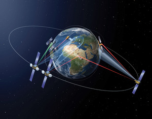 European Data Relay System (EDRS) connecting LEO and GEO satellites together - confirming the concept of the SpaceDataHighway to benefit disaster management, security and commercial users.
ESA is currently demonstrating the long distance laser link with real content from the Sentinel-1 Earth observation satellite in LEO orbit via Alphasat communications satellite in GEO orbit to the ground. During the demonstration, data transfer reached 0.6 Gigabits per second of possible 1.8 Gigabits per second over 45,000km between sophisticated Laser Communication Terminals. The demonstration follows on successful LCT operation between two LEO satellites since 2008. With such high bandwidths possible, the SpaceDataHighway will significantly improve data latency and system reactivity, making truly global near-real-time communication services available for the first time.
The SpaceDataHighway is realised within a Private Public Partnership between ESA and Airbus Defence and Space (www.esa.int/eo; www.esa.int/telecom). As the prime contractor, Airbus Defence and Space builds, owns, operates and co-finances the system infrastructure both on the ground and in space. The technology used by the Laser Communication Terminal has been developed in Germany and supported by the German Aerospace Center DLR based on funding by the Ministry of Economics.
"This is a major step in the proof of the concept. Once operational, the EDRS - SpaceDataHighway will move boundaries of space-based data communication significantly," said Evert Dudok, Head of the Communications, Intelligence and Security (CIS) Business Line at Airbus Defence and Space. "Besides Copernicus, the SpaceDataHighway will also serve many commercial and military applications that require such unparalleled near-real-time, high bandwidth communication services," said Mr Dudok.
Thomas Müller, Head of the Electronics Business Line at Airbus Defence and Space, said: "Our laser communication technology will revolutionize earth observation and satellite communication. We are the first company which masters this new technology to open up an entirely new spectrum of communication."
A part of the available SpaceDataHighway capacity will be used for data communication on ESA's Earth observation project, Copernicus. The system will therefore enable faster, more efficient transfer of large near-real-time data of the Earth. This capability is also key for security organisations or emergency response organisations. The remaining bandwidth will be commercially available, and is expected to be used for diverse applications. These include Open Ocean Surveillance (OOS) where the SpaceDataHighway will provide much-needed, low latency downlink capabilities, supporting maritime border control and providing support for counter-measures against i.e. piracy and drug smuggling. The system can also provide beyond line of sight control for Unmanned Aerial Systems (UAS) and be used to control and re-configure satellites in orbit.
The radar payload of the Sentinel 1 satellite and the Alphasat satellite have been built by Airbus Defence and Space. The first operational SpaceDataHighway LCT payload has been integrated on the EUTELSAT 9B satellite, also built by Airbus Defence and Space, to be launched in 2015. A second dedicated spacecraft will follow in 2016, providing an increased field of coverage and system redundancy. Further extension of the SpaceDataHighway infrastructure with additional geostationary data relay capacities for enhanced global coverage and system capacity is currently under preparation.
Please find more information: http://www.edrs-spacedatahighway.com; www.tesat.de
Source: http://airbusdefenceandspace.com